Hackett and Longwater Gulches
Chinaman’s Gulch
Wheeler Lake
Iron Chest
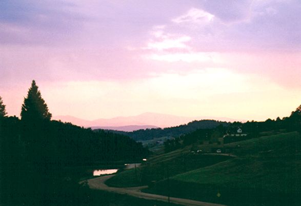 Some friends of mine decided to head out to the All-4-Fun event held around 1 August near Salida, Colorado. I thought about going, but then decided I’d have more fun if I stayed with a friend (Chuque Henry), who lives in Divide, CO, rather than sleeping in a field all week. I ended up going out a couple weeks later (mid August) and spent a long weekend wheeling with him. The photo at right is a sunset viewed from Chuque and Hannah’s front porch. Killer view, huh?
I’ll spare you the gory details of the trailer problems we had out and back. BTW, if you need to install a 4-wire trailer harness on a ’91-97 (yes, ’97) Wrangler, the cleanest way to do it is with a pre-made harness that plugs right into your existing tail light connectors. No messy splicing of wires. Just unplug the factory wiring connector to each tail light, then plug it back in on either side of the connector that comes on the wiring harness. Very clean. Dealers quoted me anywhere from $28-85 for a Mopar harness like this, but O’Reilly only wanted $20 for an aftermarket harness: Hoppy part number 42605. They had to special order it, which only took a day.
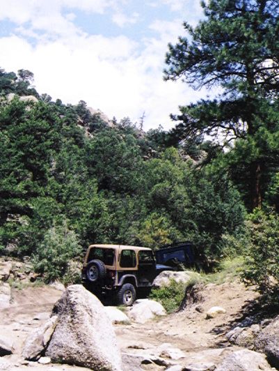
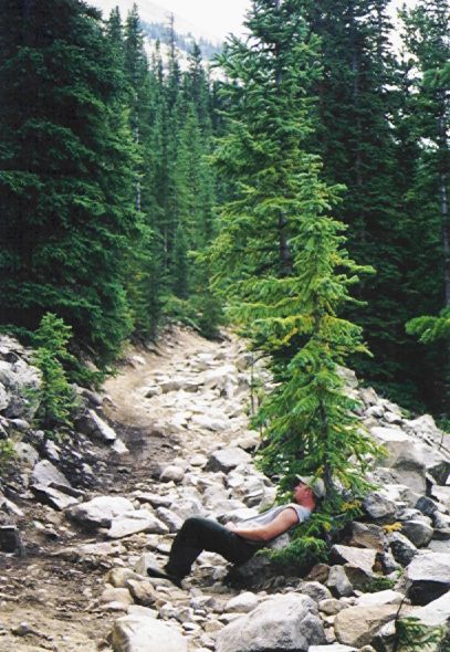
Hackett and Longwater Gulches, 16 Aug 2001
We drove out overnight & arrived in Colorado Springs Friday morning. After hanging out at my aunt’s house, we headed home with Chuque that evening after work. At 8pm that evening, we met third guy at the Hackett Gulch trail head. Chuque led in his ’82 Mercedes Gelaendewagen (33’s and dual lockers), I followed in my ’95 Jeep YJ (33’s, open), and Brian Henry (no relation to Chuque) tailgunned in his Toyota pickup (35’s & dual lockers). This was my first real night run, and the tiny fog lights I had installed did a great job illuminating the trail around me.
Hackett is practically in Chuque’s back yard, so he runs that trail all the time and is very familiar with it. With his dual lockers, he walked right up Hackett Rock — the first and largest obstacle on the trail. My open diffs presented a problem there, especially since a puddle that had collected right below the rock made my tires and the rock itself pretty slippery. I got most of the way up, but finally decided not to risk snapping my Dana 35 rear axle, and had Chuque strap me up the rest of the way. Brian tried to follow my line up the rock, but even his dual lockers didn’t help now that the rock was all wet. Chuque finally suggested a different line, and Brian made it up and over unassisted.
The remainder of Hackett was fairly uneventful. There were one or two spots where I took a different line to avoid loose, mogulled ground, but really nothing to write home about. The infamous Mogul Hill has been closed off, and the bypass presented no problems. At the end of the trail, just within sight of the South Platte River, Brian took a short detour known as Axle Breaker. It’s an uphill section filled with large boulders. Most people crawl over it, but Brian opted to hit it with plenty of throttle — much to the surprise and entertainment of Chuque and me. He banged lots of parts on the rocks, but made it up on his first run. We discovered later that Brian had been drinking out on the trail, which explained his behavior. Drinking and driving should never mix, regardless of the terrain you’re traveling or the speed at which you’re moving.
Crossing the river provided some entertainment. The shallow route turns downstream a bit before turning back upstream just before the exit point. Chuque, however, went straight across. The water flowed up over his hood, but he kept the engine running by maintaining a steady speed with a good wake. I took the shallower route, since this was my first time across the river (I’d run the dry portion of the trail twice before). Dunking my hot fog lights into the ice-cold water cracked both lenses. Oh well, they were cheap and they still work. The water on the shallower route came up to my front marker lights, which are about 30″ high.
After the first river crossing, we turned north along the river to make our return route out Longwater Gulch. One long water crossing required heading upstream until almost reaching the far bank, then turning back downstream to the exit point. The water was fairly shallow, but a mud pit on the other side enticed Chuque into it and wouldn’t let go. The pit was deeper than Chuque’s hood was tall. Space was tight behind him, so I had to double up my 20′ tow strap in order to pull him out without running into the fence behind me.
The final water crossing (before heading back out Longwater Gulch) was short, but we had to avoid a large, mostly-buried rock right in the middle. Chuque and I made it across without incident, but Brian (whose judgment was now obviously affected by alcohol) decided to straddle it. He hit it with a resounding bang, verifying that Chuque’s warning was accurate, but managed to avoid breakage.
The first obstacle on Longwater is a long, loose, heavily-mogulled hill right below a power line. Open diffs on this hill would require a perfect line, and I didn’t think I could pick such a line in the dark. I opted for the bypass, which is extremely easy. It’s too bad there wasn’t a more entertaining bypass.
The only other obstacle of note on Longwater was a large rock that was somewhat difficult to navigate in the dark with open diffs. Chuque and Brian made it up on the first shot with their dual lockers, but I had to make half a dozen runs before I finally found the right combination of line and throttle to get to the top (lifted wheel and all).
Chinaman’s Gulch, 17 Aug 2001
Way too early the next morning, Chuque and I began the 90-minute drive from Chuque’s house down to Chinaman’s Gulch. This trail is just southeast of Johnson Village, which is near Buena Vista. Follow the dirt road east of the Arkansas River south for a mile or so. A narrow corridor of public land between two private farms will lead you east toward the bluff that houses Chinaman’s Gulch. There’s a gate at each end of this corridor; please leave the gates as you found them (open or closed).
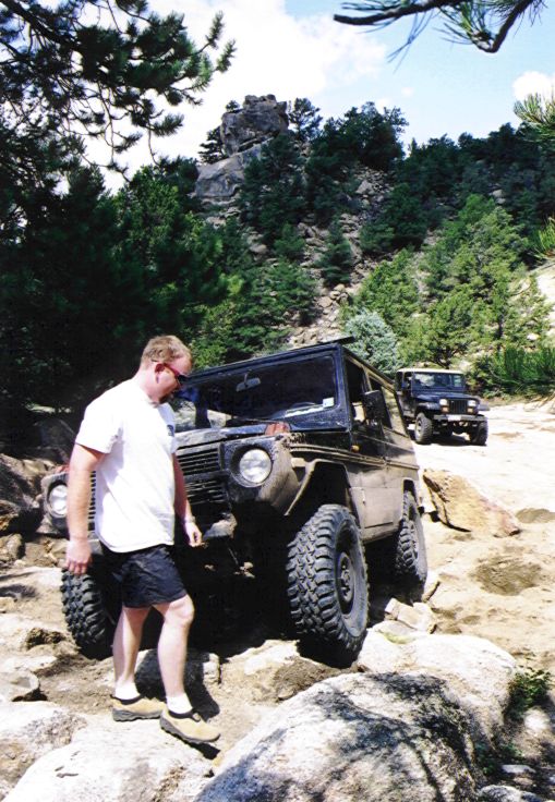
Chuque on a detour
A steep climb on a mild, rock-covered trail leads quickly up to the top of the bluff. The first obstacle is called “The Squeeze.” The trail is just narrow enough and has just enough large rocks that a Jeep- or G-wagen-sized vehicle has to pick a perfect line to wind through the boulders. A sammy would probably wind through with no problems, and a full-size with 44″ tires could just walk right over the boulders. I managed to scrape up 3 hubcaps, cracking one of them. (I removed them for good upon returning home.)
A little farther down the trail, Chuque decided to try a short detour that was basically a large pile of boulders. His dual lockers were certainly required, but he really could have used a few more inches of clearance under his frame. He got hung up a lot, but several well-stacked rocks finally allowed him to slide through. He really needs a suspension lift! I’ve gotten skittish about my rear axle, so I avoided the rock garden. If I’d had a rear locker (and a stronger rear axle), I probably could have made it through much more gracefully than Chuque, due in large part to my increased ground clearance.
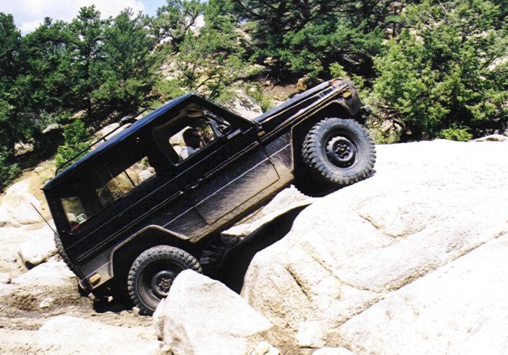
The Waterfall on the Chinaman’s Gulch trail
The only big obstacle on Chinaman’s is called “The Waterfall.” I’m not sure why, since there’s no water nearby. It’s a large slab of granite that must be climbed. The easier lines are to the right (as you’re going up), and the harder lines are to the left. Chuque tried one in the middle. He raised a wheel several feet in the air and almost rolled before finally picking a good enough line to climb up and over. I expected the far right line to offer a little challenge, but it was easier than I expected, allowing me to walk right over on the first attempt. We stopped for lunch at the top.
Chinaman’s Gulch lunch stop
Shortly after lunch, Chuque tried to squeeze between two trees and managed to mangle his right rocker panel on a rock. Oh well, he was going to cut that off anyway. Later that day (I forget exactly where), he mangled the left one, so at least he returned home with a matched set.
We took one detour that squeezed between a tree and a rock wall. Chuque’s line took his roof just inches from the outcropping. A sharp 3-point turn (or in Chuque’s case, a 9-point turn) through a little rock garden directed us over another largish rock to the exit.
One of the nearby landowners has dammed up a stream that ran through the gulch, producing a pretty little lake. A little spur off the main trail crossed part of the lake and climbed a short, steep hill to a scenic dead end by the lake. It was a fun photo stop. The rest of the trail wound through uneventful terrain before heading back down The Squeeze and out to the road. Chinaman’s Gulch doesn’t have your stereotypical Colorado scenery, but it is a technically fun trail to run. We enjoyed it.


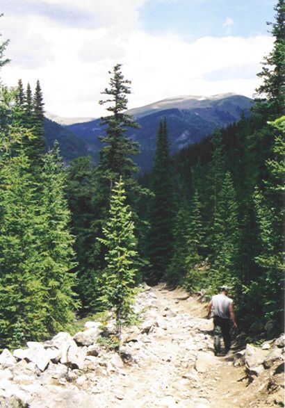
Wheeler Lake, 18 Aug 2001
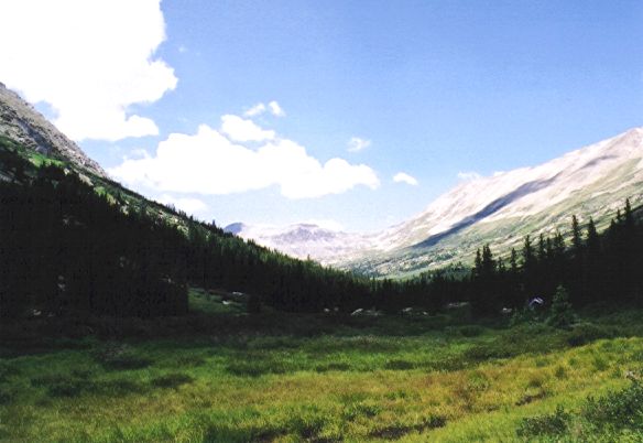
Wheeler Lake scenery
Chuque accurately billed Wheeler Lake as the most scenic trail on our schedule, so our families (Chuque’s wife Hannah, my wife Stacy, and my 18-mo-old son Micah) joined us that day. Wheeler Lake is another 90-minute drive from Chuque’s house, lying roughly between Breckenridge (to the north) and Fairplay (to the southeast). A mile or so after leaving pavement, the gravel road leads around the far side of Montgomery Reservoir to an old mining building, which is the start of the trail. A pretty waterfall lies on the far side of the building. The trail runs through a valley and follows alongside and sometimes through that stream throughout the climb past the tree line to Wheeler Lake.
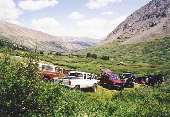
While gassing up in Fairplay, we ran into the Colorado Springs Christian 4-Wheelers club, half of whom were also heading to Wheeler that day. We jumped in with them, which provided a fun change of pace. They’re a friendly group, if a little slow-moving on the trail. Also arriving at the trail the same time as us were a few people who claimed to be heading up the trail to some land they owned. They were arrogant, unfriendly, and didn’t know much about off-road driving. However, they provided some very entertaining video clips on the tougher obstacles and were the butt of several jokes after we parted ways.
There have traditionally been three major rock obstacles on the Wheeler Lake trail. The first has two basic routes. To the left (while climbing) is the easier route, which should be easily navigable by most stock 4×4’s. To the right is a wedge that runs somewhat diagonally up the rock. Climbing the wedge can lead to some very off-camber situations, and definitely requires lockers. Descending the wedge on the way back down is much easier, but still requires a trustworthy spotter to keep you from slipping down into the wedge and possibly lying on your side.


The second obstacle has three basic routes. The straight-ahead route, which is the right-most when ascending the trail, is the hardest. It requires straddling another, larger wedge. At least one locker appears to be mandatory to give the amount of control necessary to avoid slipping into the wedge. The easiest route starts toward the right, but then makes a sharp left turn to climb over a mild ledge to the flat area on top of the rock. The medium route swings far to the left and then climbs a bumpy incline up to the top. Decent articulation makes this route a no-brainer, but it might challenge stock vehicles.


Did I mention that Wheeler Lake was a gorgeous trail?
A little farther down the line is a large mud hole that’s scattered with large rocks. I’m told that this perennial mud hole wasn’t as threatening today as it has been in the past. Still, care should be taken not to hit any submerged rocks with too much throttle.
Lunch stop at Wheeler Lake
We stopped for lunch just a quarter mile below the lake, right near the tree line. A little spur trail heads downhill to the left and leads to a clearing within view of the main trail. This was the last spot below the lake that’s large enough for multiple vehicles to pull off and allow oncoming vehicles to pass.
After lunch, we began a very steep climb up a stream bed full of loose, wet rocks. Chuque’s questionable clutch (courtesy of the Waterfall on Chinaman’s Gulch) gave him more trouble here, and he had to take the hill in several quick spurts rather than one slow climb to avoid killing his engine. Upon rounding the first corner, we found the the third big obstacle, which used the be the most menacing of the bunch, had been blasted to smithereens. It might still provide some challenge to stock vehicles, but it was easy enough with a well-modified Jeep that I didn’t even recognize it on our trip up. It wasn’t until we finally reached the end of the trail at the lake that we realized that that must have been the remnants of the third obstacle. When heading back down, I took a tougher line, and managed to raise a tire just to make things interesting.
The lake at the top of the trail was really pretty. It supposedly offers decent fishing, although we never saw anyone catch anything. We hung out there for a while before loading back up & beginning the much-quicker decent back to the trail head.


Iron Chest, 19 Aug 2001
Iron Chest has long been billed as one of the hard trails in Colorado, but this rating has diminished considerably with the opening of trails like Independence and Die Trying. Neither Chuque nor I had done it before, but we figured it would be a fun challenge. The trail is located straight above the ghost town / tourist trap of St. Elmo, just west of Nathrop and southwest of Buena Vista. The 2.5-mile, one-way trail leads to the old Iron Chest mine. The first half mile or so contains all the really nasty stuff, and we were told (with some accuracy) that the remainder of the trail was considerably easier.
We had some trouble finding the trail. If you hit the town of St. Elmo, you need to turn around and backtrack about half a mile, then take the south fork in the road. A little ways past that fork, you’ll see a small parking area on the left that is the base of the trail. There are no signs marking the trail.
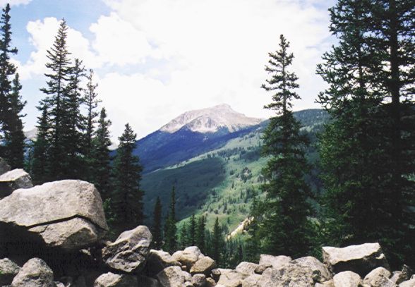
View from the Iron Chest trail
The lower end of the trail (the nasty part) is basically a landslide of basketball-and-bigger-sized rocks. Since I had a wimpy axle and I had to drive home to Nebraska just a few hours later, I rode shotgun with Chuque for what we thought would be a short scouting trip of the trail before heading up with my YJ. After all, he was locked front and rear, and he lived nearby anyway. Since Chuque had a bad clutch and a small engine, he did his best to maintain momentum over the boulder field. This made for an extremely bumpy ride. Using that as my guide, I opted to just leave my YJ parked and ride the whole way with Chuque. In retrospect, I could have slowly crawled through that mess and probably done just fine with my flexible suspension and oodles of clearance. We still had fun, though.

View from the Iron Chest trail
The first half mile or so was hands down the bumpiest section of road that I had ever been on. It’s wide enough that you have some choice of which line to take. There are even a couple spots in this section that are wide enough for two vehicles to pass. We made it through the nasty section with sore kidney, but otherwise unharmed. From there, the trail got smoother and narrower. The trees on the downhill side got thinner, but still generally dense enough to prevent you from rolling to your death if you got too close to the edge. Although this was supposedly the easy section, there were occasional obstacles in the form of very large rocks that had fallen from above into the middle of the trail. We were able to negotiate one pair of such rocks with only minor undercarriage scraping.
The other nasty feature of Iron Chest comes several hundred yards after the bumpy rock garden ends. This is a series of short ledges that run diagonally across the trail. The trail is only about as wide as a full-size there, which leaves even a Wrangler or G-wagen very little wiggle room and makes you very off-camber when traversing these ledges. The situation is made worse by the fact that there is a gap in the trees at this point which would allow you to roll a hundred feet or so straight down before coming to a stop, should you venture too close to the edge. I quickly offered to get out and spot Chuque over the ledges from a safe distance uphill. He didn’t need my ballast on the downhill side, anyway. Chuque did OK and didn’t appear (from my angle) to be in any danger of rolling, but he said it was one of his scariest off-road experiences — so far.
Chuque resting on the Iron Chest trail
About 100 feet past the off-camber section, we met our match on another pair of fallen boulders. Chuque’s G-wagen could have climbed the front wheels over the rock, but he would have high-centered his frame on it. With no winch, no buddy vehicle, and no nearby rocks large enough to stack, we called it a (short) day. By all reports, we had already conquered the difficult portion of the trail, and except for a spurious fallen boulder, had only the scenic portion ahead of us. The portion of the trail ahead that we could see confirmed this. We took a short break there before heading back down. The views from the trail were quite scenic when you could see through the trees. At one point, I could see what I assumed to be the rooftops of St. Elmo in the valley straight below us. I’m told that the views from the summit by the mine are incredible.
Chuque walking the Iron Chest trail
Now came the really fun part. Because the trail was far too narrow to allow even a short vehicle to turn around, Chuque had to back down the trail until a wider spot was found. This meant backing down the off-camber ledges that had scared us so when coming up. Chuque said this was easily his scariest off-road experience. This was made worse by the fact that he kept mentally reversing my spotting instructions and turning the wrong way. Not good. Fortunately, he was going very slowly, and therefore had time to correct himself before he drove off the cliff.
About half way down the rock garden, we met three Jeeps coming up. This occurred at the widest part of the trail, so Chuque was able to pull off to one side and allow them to pass. The second Jeep was the sweetest looking XJ I’ve ever seen. All four doors were removed, and the back portion of the roof, including the rear side windows and tailgate window, had been cut off, leaving an open back end much like a full-size Bronco. The owner planned to make a custom soft top for it. I’ll make a video frame grab of it sometime soon. The third Jeep was basically stock, with no lift and 31″ tires. He banged a lot of rocks, but was making it up OK. I wish we’d had time to follow them up to the rock that stopped us, but it was already mid-afternoon and was starting to rain, so we finished our decent and headed home.
Do you like this site?
Help me keep it going by throwing a few pennies my direction.
![]()
![]()
![]()
![]()
Links on this page to Amazon are part of an affiliate program that helps keep Jedi.com operational.
Thank you for your support!